
Lynbrook ZIP Directory Coverage
The verified postal ZIP for Lynbrook is 11563. The USPS exact-address lookup is the authority for a mailing ZIP, while Nassau parcel records establish a property’s tax and title connections. Only officially verified coverage is included. Nearby postal offices and nearby ZIPs are not additional verified ZIPs for the incorporated Village of Lynbrook.
| ZIP | Areas Covered | Post Office | Notes |
|---|---|---|---|
| 11563 | Lynbrook preferred postal city | Lynbrook Post Office, 100 Broadway, Lynbrook, NY 11563-3279 | Standard ZIP. Use the USPS exact-address tool for a specific mailing address. |
The USPS location search also identifies alternate offices in East Rockaway, Rockville Centre, Valley Stream, and Franklin Square. Those locations help with postal service choices, but they do not prove that their ZIPs serve Lynbrook. No official USPS boundary polygon or address-level exception list for the village was located, so edge addresses deserve an address-by-address check.
Lynbrook Postal Geography for 11563
Lynbrook lies in the Town of Hempstead in Nassau County, and its postal geography is not the same thing as its incorporated-village boundary. USPS treats Lynbrook as a preferred postal city for 11563. A preferred city line can extend beyond a municipal boundary, while a nearby community can use a different postal label even when streets and services feel continuous. The parcel, its SBL, and the village or place-boundary layer answer a jurisdiction question more reliably than the mailing ZIP.
The Lynbrook Post Office at 100 Broadway is the verified local retail location, with the postal ZIP shown as 11563-3279. A counter location is useful for service information, but it is not a municipal map. For an edge address, compare the standardized USPS line, the Town of Hempstead and Nassau parcel record, and the village boundary layer before deciding where a request belongs.
Postal boundary check. A Lynbrook postal name can be correct for mail while the address is outside the incorporated village, so verify both the mailing line and the parcel jurisdiction.
Check a Lynbrook Mailing ZIP
The USPS tool accepts a complete residential or corporate address with city and state, then returns the ZIP, ZIP+4, and standardized mailing line. Enter the street number and street name exactly. Preserve the postal response in a search log rather than replacing a historic place label with a modern one. The result is authoritative for mail delivery, but it does not provide a title boundary, a tax parcel, or a list of residents.
For a 1928/29 directory, newspaper, map, or deed, retain the original place name alongside the modern USPS result. Older Lynbrook-area records may say Bloomfield, Pearsall’s Corners, Pearsalls, or Near Rockaway. The current mailing ZIP is a cross-reference, not a reason to rewrite the historical record.
Note: USPS supplies a mailing result, while Nassau parcel and boundary systems answer questions about municipal jurisdiction and title.
Lynbrook Parcel Search by ZIP
The Nassau Land Records Viewer accepts an address route with house number, street, town, and ZIP, as well as a Section, Block and Lot route. It returns assessment and parcel information, not a ZIP-wide roster. If a full street string fails, Nassau instructs searchers to remove the directional prefix and street suffix, then try the street name or its first few letters. That local search quirk is often more useful than broadening a name search.
The Land Records Viewer address screen is a practical starting point when a Lynbrook ZIP narrows a known property.
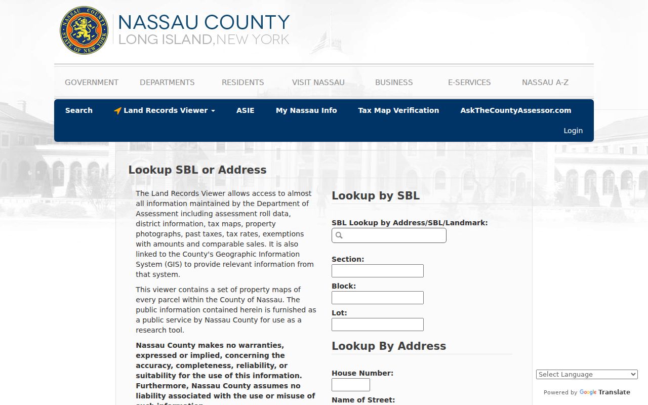
Use a successful parcel result to capture the situs address, owner or taxpayer field, mailing address, and SBL. The owner or taxpayer is not necessarily the current occupant, and a tax mailing address can be elsewhere. The SBL, rather than a ZIP, is the stronger bridge to deeds and map records.
Lynbrook ZIP Fields in Assessment Search
Nassau’s AROW property search is another ZIP-capable route. Its captured form requires Street and ZIP and exposes number or house number, street name, city postal name, Section, Block, and Lot. These fields let a searcher test one property against the postal result, then move to parcel and title work. They do not turn 11563 into a complete directory of persons.
| AROW field | Use for a Lynbrook ZIP search |
|---|---|
| House number | Pairs the search with one physical address. |
| Street name | Required field; omit direction and suffix if an exact entry fails. |
| City postal name | Checks the postal label but does not settle village jurisdiction. |
| ZIP | Required filter in the captured AROW form; verify it first with USPS. |
| Section, Block, Lot | Supplies the legal parcel bridge when address text is ambiguous. |
The Nassau AROW property-search form shows the required ZIP and street fields.
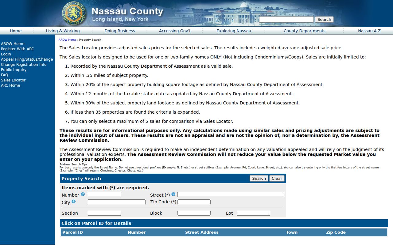
Once an AROW or LRV result supplies an SBL, keep that exact notation when moving to the County Clerk index. Nassau warns that Clerk and assessment systems can format SBL placeholders differently, so compare the official deed or tax-bill record rather than guessing at a changed value.
Search a Single Lynbrook ZIP Code
A ZIP filter works best as part of a one-address workflow. It narrows a search to the correct postal context, then the parcel, deed, court, voter, license, or history source answers a separate question. No documented public portal provides a complete ZIP-wide resident roll for Lynbrook.
- Run the full address through USPS and record the standard city line, ZIP, and ZIP+4.
- Open LRV or AROW with the house number, street, Town of Hempstead, and verified ZIP. If the search fails, omit a directional prefix and suffix, then try a street-name prefix.
- Save the parcel address and SBL, then use the Nassau map to view the parcel and the village or place boundary. The parcel is the title and assessment key.
- Use a deed, court, voter, license, or historical source only for its documented purpose. Preserve its date and identifier before treating it as a cross-check.
After the postal and parcel checks identify a street, the Lynbrook street directory has the address-by-address record trail. The ZIP step should narrow the geography, not replace street-level verification.
Note: A ZIP filter narrows postal geography, but the parcel and its SBL remain the stable keys for assessment and deed research.
Lynbrook Voter and License ZIP Fields
New York’s voter-status form exposes a ZIP field, but it also requires a known person’s last name, first name, date of birth, county, and address information. It cannot browse a ZIP for households or neighbors. A full voter-data request is different from the public form and requires an elections-purpose statement under Election Law § 3-103(5). Confidential registrations remain outside ordinary inspection.
The NYS Licensee Name Search also accepts ZIP as a narrowing field along with name, license type, county, or city. A result can help distinguish similarly named licensed people through a profession, license number, date, or status. Its location field is a record clue, not an assertion of a home address.
Nassau’s public GIS parcel layer supplies parcel address and geometry but did not expose a ZIP field in the inspected metadata. Use the postal tool and assessment forms for ZIP, then use the Nassau parcel map for the boundary and parcel context.
Lynbrook ZIP Boundaries and Village Limits
Postal-city and village boundaries answer different questions. USPS assigns an address for delivery. Nassau assessment and Clerk systems tie property to the parcel and SBL. The Village map and county place-boundary layer show municipal context. A street can cross a municipal edge, and a familiar postal city can extend beyond it. Keep all of those fields instead of choosing one as the universal answer.
Four terms help keep the record trail clear:
- ZIP
- A five-digit postal routing code used to direct mail to an area or delivery unit.
- ZIP+4
- An added four digits that identify a smaller delivery segment within the five-digit ZIP.
- PO box ZIP
- A postal code used for post-office boxes and not necessarily for street delivery addresses.
- Unique ZIP
- A postal code assigned to one organization or delivery unit, not a general municipal boundary.
- Carrier route
- A mail-delivery sequence used by USPS; it does not establish village membership or property ownership.
Lynbrook Historical Addresses Before ZIPs
ZIPs are modern postal references, so they should not drive a historical search. The verified Lynbrook city directory is a 1928/29 microfilm holding at the New York State Library, and historical maps include the 1906 and 1914 Lynbrook views, the 1919 Sanborn sheets, and Nassau’s 1926 and 1950 map layers. These sources can connect an old street or lot to the modern parcel without pretending that an old entry used today’s postal language.
Lynbrook became the effective place name in 1894 after earlier use of Bloomfield, Pearsall’s Corners, Pearsalls, and related labels. Search those terms beside the modern name in older newspaper, deed, map, and directory work. An old place label may be the key to finding a record that a ZIP filter cannot reach.
The historical comparison has a practical access benefit. The New York State Library holds the verified 1928/29 Lynbrook directory on onsite, non-circulating microfilm, while the Lynbrook Public Library and Historical Society point researchers toward local newspapers, New York Heritage material, and historic maps. A searcher can first capture the original street spelling and publication date, then compare it with the 1919 map sheet, a modern parcel, and the USPS mailing line. That sequence preserves the old record’s meaning without assuming a postal label existed at the time.
Lynbrook ZIP Code Gaps to Verify
No official Lynbrook ZIP split or realignment year was located, and no official per-ZIP population or registration statistic was found in the reviewed sources. Do not treat a nearby ZIP, an online boundary sketch, or a postal-city label as proof of an exception. For a disputed address, get the standardized line from USPS and confirm the municipal boundary separately with Nassau or the village.
Note: Keep the returned ZIP, ZIP+4, parcel SBL, source URL, and search date together so a boundary or delivery question can be checked again later.