
Trace a Lynbrook Street
A street-by-street search starts with one real address, not a guessed household name. Nassau County's assessment tools tie that address to a parcel, then the map places it among the other lots. The next record may identify an owner, taxpayer, or recorded party. None of those labels automatically identifies every person at the address. Keeping the address, Section, Block, Lot, source date, and result type together prevents a map hit from becoming a claim about a current household.
- Enter the house number and street in the Nassau Land Records Viewer. If a full street label fails, omit the direction and suffix, then try a short street-name prefix.
- Save the situs address, owner or taxpayer label, mailing address, and Section, Block, Lot. Open the same parcel in the map and inspect nearby lots one at a time.
- Use the Nassau County Clerk land-record index to find the current conveyance and then work backward through grantors and grantees.
- For a person already known, the state voter form can corroborate an individual registration status. It is not a public street browser and requires the person's identifying details.
- For historical context, inspect the verified 1928/29 Lynbrook directory film onsite, then compare its date with newspapers, maps, and census releases.
That order keeps the modern search address-led. It also separates a deed's legal party from a present resident, and a tax mailing address from the physical parcel.
Lynbrook Street Search Fields
The Land Records Viewer and the county's AROW property route offer the most direct start for an address search. The basic LRV form accepts the Section, Block, and Lot components as well as house number, street, town, and ZIP. AROW marks street and ZIP as required on the captured form. Lynbrook lies in the Town of Hempstead, but a postal city label should not be used as a substitute for parcel or village-boundary verification.
| LRV field | Input type | When used | Lynbrook search note |
|---|---|---|---|
| Section | Text | SBL route | County Clerk and Assessment formatting may differ. |
| Block | Text | SBL route | Copy it from the official tax or deed record. |
| Lot | Text | SBL route | Use the legal parcel, not an assumed lot number. |
| House Number | Text | Address route | Numbers can be numeric or hyphenated. |
| Name of Street | Text | Address route | Omit directions and suffixes; a prefix can broaden a failed search. |
| Town and ZIP | Text or selector | Address route | Use Town of Hempstead and verify the postal result separately. |
The county warns that its Assessor and Clerk systems can display the same SBL with different placeholders. When the address trail moves from LRV to a recorded document, copy the Clerk's official SBL rather than retyping a reformatted version.
Note: Retain the original search spelling, since a partial street prefix can return a broader result set than a full address.
Lynbrook Street Map Layers
The Nassau parcel map is a visual route through a street, not a roster of people. Search an address, turn on Parcels and Lots, use Identify on the target polygon, and then pan along both sides of the road. The service exposes parcel address and roll-year fields such as PARCEL, PARCELKEY, PARID, and PARCEL_ADDRESS. The parcel layer does not promise the full owner record, so use it to reach the linked assessment trail.
The county map also offers roads, railroad, parks, village and place boundaries, aerial context, flood zones, and measurement tools. Nassau County 1926 and 1950 layers can help test whether a road or lot was present before a directory or deed hit. They are context layers, not a legal survey. A railroad right-of-way, park, or large lot can make visual adjacency different from the next household on a street.
| GIS control | Input type | Required | Street-search use |
|---|---|---|---|
| Search by Address | Text | No | Map zoom and search route. |
| Search in | Selector | No | Live-viewer choices were not fully rendered in the text inspection. |
| Go and Clear | Buttons | No | Run or reset the map search. |
| Parcels and Lots | Layer toggles | No | Show parcel polygons, lot lines, and labels. |
| Roads, Railroad, and Parks | Layer group | No | Add street and block context. |
| Village and place boundaries | Layer group | No | Compare municipal and place context. |
| Aerial and historic maps | Layer toggles | No | Aerial 2013, county 1926/1950, and NYS 2000-2013 comparisons. |
| FEMA Flood Zone | Layer toggle | No | Flood-overlay context for a parcel. |
| Identify | Tool | No | Click a parcel or map feature to inspect attributes. |
| Area, Distance, and Location | Measurement tools | No | Measure with unit selection and latitude or longitude output. |
The captured Nassau GIS parcel viewer shows the map-based starting point for a Lynbrook address search.
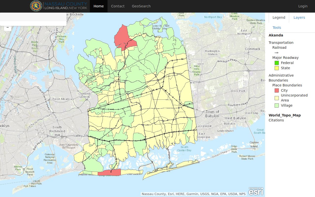
Use the visible parcel context to make a short list of lots, then confirm each one in the assessment record rather than treating map proximity as proof of a shared household.
Lynbrook Street Address Meanings
A property record can put several addresses on the same screen. The situs is the physical parcel address. A mailing address is where tax notices go, so it may point to a trust, a relative, an attorney, or an owner outside Lynbrook. A recorded document's return address is a delivery instruction for that transaction. It should not be read as a present residence. Each label has value, but each needs its own interpretation.
- Parcel
- A defined piece of land shown in the assessment and map system, usually tied to a parcel identifier and SBL.
- Situs address
- The physical street address of the parcel, which may differ from the address used for tax mail.
- Plat or subdivision map
- A recorded map that shows lot and road layout, useful when an older street label does not match a modern address.
- Criss-cross directory
- An address-ordered part of some historical directories. A Lynbrook-specific reverse run has not been verified, so inspect the 1928/29 film onsite before relying on one.
New York's voter-file layout makes a similar split between residence fields and separate mailing fields. That technical distinction is useful as a caution, not an invitation to compile a street list. The public voter form remains an individual status lookup.
Lynbrook Street Deed Trail
After LRV supplies the SBL and indexed owner or taxpayer name, the County Clerk's land-record index can locate deeds, mortgages, satisfactions, maps, liens, and related filings. Search a current owner as grantee or buyer to find the purchase document, then use its grantor or seller as the next earlier name. At each stop, compare the legal description and SBL. A matching street line alone can be misleading when numbering or subdivision context has changed.
The electronic database begins in July 1992, but Nassau's land registry reaches back to 1899. Earlier research may require the Clerk's public computers, liber books, property cards, microfilm, microfiche, or Records Center retrieval. The Clerk cannot supply ownership information by telephone or email. Bring or send the address, SBL, parties, approximate recording date, document type, and any index or instrument number when a counter or written request is necessary.
The captured Nassau County Clerk land-record index is the recorded-document route used after the Lynbrook parcel search.
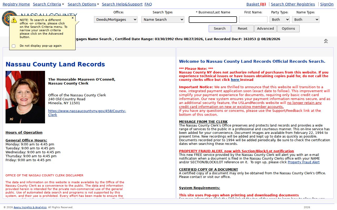
A deed index hit proves that a document was recorded. It does not prove continuous residence by a grantee, and a record-and-return address remains only a transaction clue.
Note: Match the legal description and SBL at every transfer, even when the street address appears unchanged across the recorded documents.
Lynbrook Street Permit Files
The Lynbrook Building Department holds another address-keyed trail at One Columbus Drive. No public permit-search database was found. Its published application material asks for Number and Street, Zone, Section, Block, and Lot, and it can associate a dated application with an owner, applicant, contractor, plans, inspections, or certificate of occupancy or compliance. Request a specific address or SBL, a date range, and the record types needed.
Permit material can help date an alteration or explain a changed footprint on the map. It does not create a complete current street list. The application instructions list an approximate two-to-five-week review for new submissions and require 24-hour notice for inspections, but historic file access depends on the custodian and the file. Ask whether application, inspection, plan, certificate, and disposition records are available before assuming a full file exists.
Lynbrook Street Voter Limits
The New York voter lookup asks for county, last name, first name, date of birth, address information, and ZIP. It can help an already identified registered voter locate status, poll-site, or mail-ballot information. It does not offer a public way to browse everyone on a Lynbrook street. A non-match can reflect a changed legal name or address, inactive or protected status, or a search error. It is not proof that a person is absent from the community.
The state file layout contains residence, apartment, ZIP, district, and separate mailing fields, but Election Law § 3-103(5) limits statewide-list use to election purposes. Confidential registrations under Election Law § 5-508 are held apart from ordinary inspection. Those limits are part of an accurate address method: use public forms for their stated individual function and do not turn protected or specialized records into a household inventory.
Note: A public voter-form result is an individual status check, so it should not be treated as a street-wide household result.
Lynbrook Street Name History
Older street research needs more than a modern postal label. Local histories use Bloomfield, Pearsall's Corners, Pearsalls, and Near Rockaway before Lynbrook became effective in 1894. The village incorporated in 1911. Search those place-name variants alongside Lynbrook when an old newspaper, map, or directory seems silent. The research did not locate an official street-by-street renumbering or renaming register, so a citywide renumbering date should not be assumed.
Compare the 1906 and 1914 historic maps, the February 1919 Sanborn sheets, Nassau's 1926 and 1950 map layers, subdivision maps, and the modern SBL. A 1929 court case refers to territory annexed in 1921 and a Lyndwood Manor subdivision map filed in 1926. That is a reason to check official map filings before making a street-boundary conclusion, not proof about any one present address.
Note: Keep the historical place name in a research log, then add the modern parcel reference rather than silently replacing the original location label.
Lynbrook Street Records
The useful street directory sources are keyed to an address, parcel, or recorded document. They do not all speak to the same date or person. Read them as a chain: LRV identifies the parcel, GIS shows the physical context, Clerk records document property transactions, and village files can date changes. Historical sources can add a name or street association, but their coverage is not continuous.
| Address record | Custodian | What it can show | Access route |
|---|---|---|---|
| Assessment roll and LRV | Nassau Assessment | Owner or taxpayer, mailing and situs addresses, SBL, values, exemptions, photos, tax and sales data | Free LRV; assessment questions at (516) 571-1500 |
| GIS parcels and maps | Nassau GIS and Assessment | Parcel polygon, address, lot, boundaries, historic and flood layers | Free map with Identify and measurement tools |
| Deeds, mortgages, and maps | Nassau County Clerk | Parties, recording details, legal description, SBL, maps, and related instruments | Electronic index from July 1992; older media and counter routes |
| Subdivision plats | Nassau County Clerk map room | Lot, block, road layout, subdivision reference, map date | Map room or indexed land-record route |
| Permits and certificates | Lynbrook Building Department | Address or SBL, applicant, project, inspection, and certificate dates | Written or in-person request; no online index located |
| 1928/29 directory film | New York State Library | Dated name and address association, subject to onsite entry inspection | 7th-floor Microforms Area; non-circulating |
For a current address question, use the parcel and deed routes first. For a past street association, the directory film and newspapers are supporting layers. The historical collections are treated in detail in the Lynbrook city directory collections.
Lynbrook Street Parcel Results
AROW presents a ZIP-capable county property form with number, street name, city postal name, ZIP, and SBL fields. The system also exposes a sales-locator feature for one- and two-family homes, but comparable-sale results are informational and not valuation opinions. Use the address form to narrow a parcel before moving to the map or recorded deed trail.
The captured Nassau AROW property search shows the address and ZIP inputs that support a Lynbrook street directory search.
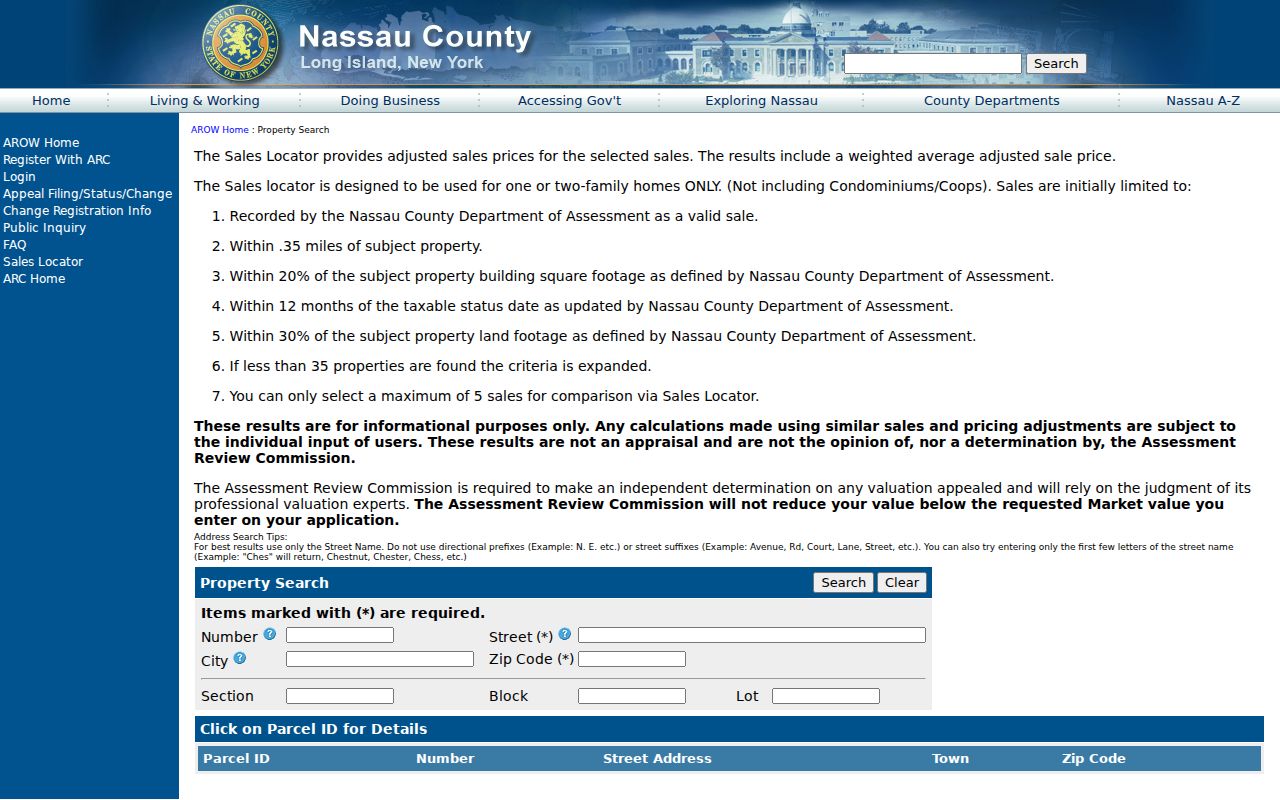
The form's city postal name and ZIP narrow an address lookup, while the SBL remains the stronger bridge to Clerk records and map filings.
Lynbrook Street Directory Limits
A street directory cannot reveal every person connected to an address. Assessment and deed records usually identify owners, taxpayers, parties, or mail destinations, not all occupants. Permit files may name an applicant or professional connected with a project. Public records do not ordinarily provide utility customers, delivery customers, DMV address data, school records, private club rosters, or Address Confidentiality Program locations. A parcel result is evidence about a parcel, not an all-purpose profile.
New York's Address Confidentiality Program supplies an eligible participant with a substitute address while protecting the actual location. Confidential voter records are also handled separately. A missing public result may be correct. Respect that boundary, retain only the identifiers needed to check a source, and ask the official custodian about correction or access procedures when a record needs review.
Verify a Lynbrook Street
A careful Lynbrook street directory result has at least two independent anchors. Match a source date with the SBL, legal description, map feature, instrument number, or archive item. The compact village footprint makes parcel browsing practical, but it also raises the chance of same-name and same-street errors. Write down whether each result is an assessment entry, a recorded document, a permit file, a directory association, or a map layer.
When the online route ends, use the channel that holds the record. The County Clerk offers public terminals, counter access, older media, and Records Center retrieval. The Building Department has a written or in-person file route. The State Library film is onsite only. That source-by-source approach is more accurate than a promise of a complete online resident roll.